Saturday, November 29, 2014

Robben Island - not such a happy place

Robben Island

Up to now, I have not written much or anything about the politics here in South Africa. And I won’t, except for this one post about Robben Island. I was pretty ignorant about what Robben Island represented, as I have not yet finished reading Nelson Mandela’s autobiography. My mom really wanted to go, and by then I did as well.

Robben Island is the prison where Nelson Mandela spent 18 years of his total 27 years imprisonment. It is the place where only black, male, political prisoners were kept. The tour starts in Cape Town at the Waterfront, we take a ferry ride to the island, which is 11 km away. It so happens that we are on the actual ferry that used to transport the prisoners, there used to be a cell below deck up front. (It cannot be seen anymore, we were just told about it)
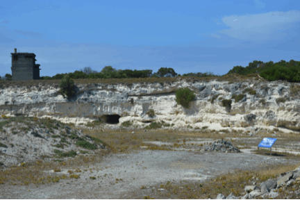
 Once there, the group gets divided into two, we first go on a bus tour around the island. Before the island became a prison, it was used to banish lepers. We stop at several spots along the way, the most important one being the quarry where Nelson Mandela and others had to do hard labour. Everyday, for 8 hours, they had to dig in that quarry. On day one, they moved the rocks from the left to the right, the next day from the right to the left. Guards watched them, with pit bulls at their sides. There was no real use for the rocks, it was just punishment. Also, the dust from the limestone, the heat and the brightness of the African sun, really was very bad on the human eye, and caused much damage. That’s why Nelson Mandela had to have eye surgery after his release and he often wore sunglasses. Of course when they were in prison, they were not given sunglasses, and that was done on purpose, too. After Nelson Mandela and the other political prisoners got released in February of 1990 (about 1100 ex prisoners), they got together at the quarry to commemorate. Nelson Mandela stood there in silence, eventually he bent down, picked up a rock, walked to the center of the quarry, put the rock down. Also silence, all the other ex-prisoners did the same. They promised each other, to get together every 5 years and to repeat this ceremony until the very last of the political prisoners has passed away. You can see the pile of stones in the picture I will post.

After the bus tour, we went to the prison building. We were greeted by an actual ex-political prisoner. There are 16 of them still living on the island, doing tours, and it was very touching. We got to sit in one of the common rooms which used to hold around 50 prisoners. He spoke for a long time, and then we could ask questions. As he was explaining life on robben island, not all eyes remained dry, that’s for sure. In the end, someone asked why he was still here, doing these tours, within the walls that kept him locked up for so long. I believe that his wish is for us to remember and to spread the word, so as to not forget. I hope I helped him just a little bit, why don’t you read up and do the same?


Actual ferry they used to transport the prisoners to Robben Island with ...


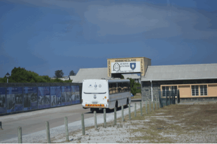
First glimpse of Robben Island, it took a 50 minute ferry ride to transfer you from beautiful 
Waterfront in Cape Town to Robben Island pain and suffering ...


Entrance to the prison buildings...


Limestone quarry Nelson Mandela and others had to work at each and every day. Notice the stone pile at bottom right beside the plaque? That's the one I mentioned above...


This plaque shows what the prisoners were allowed as rations. Not much. There is even a difference between some of the blacks, depending on their tribe, they were given different rations. However, our  guide told us, that the prisoners put it all together and shared in it equally. 


Here is a picture of our guide, an ex-prisoner. A very inspirational man...


And this is Nelson Mandela's cell. It is very tiny. The dog kennels for the pit bulls are larger...

Let all this be a lesson to us, to treat our fellow human beings with respect and equality. There is much work to be done.

Cape Town - Cape of Good Hope

Cape Town – Cape of Good Hope

We approach from the mountains, slowly making our way down to sea level. The winds are whipping up something fierce; it takes both hands on the wheel to keep the RV steady. We look and look, and there it is, Table Mountain, the landmark of Cape Town. As the saying goes “first impressions count the most” and so it is with Cape Town, and I am in love. Our campsite is actually a long way out of town, along the coast, kind of across the bay from the city. It is hazy and there are lots of clouds, yet the views are breathtaking. We are looking forward to our city sightseeing tours.

Next day we get picked up from the campground and we all go by bus. We drive along the ocean, getting closer and closer. Cape Town has around 3.7 million people, but you wouldn’t know it, everything is calm and quiet and traffic is a piece of cake. Today we only go down to the Waterfront, we get to walk around on our own, do whatever we want to do. First thing on our to do list is to go and see, if we can get tickets to visit Robben Island. This is not part of our tour, and it is hard to get tickets last minute, they sell out weeks in advance. We are lucky and are able to buy some for Sunday morning (it is Thursday today). Sunday we are supposed to move on to Stellenbosch, but we figure we can catch up with the group later that day, better to miss some Stellenbosch than Robben Island.

On Friday we have our city tour of Cape Town. As the wind has been blowing hard for days now, it is not possible to go up to Table Mountain, as the gondola is closed. But we drive up to Signal Hill, and have a wonderful view from up there. We see many sights, spend some time walking through the older parts of town, some gardens, the parliament. Funny story about the parliament: Apparently, the president has four (4) – yes 4!!! – wifes. During official ceremonies, such as the opening of parliament, only wife number one is allowed to follow him in through the main entrance. Wives 2-4 must make use of a lesser entrance, but are allowed to rejoin with number 1 on the inside!!!

On Saturday, we go on our Cape Tour, also by bus. We are excited, as we get to see the Cape of Good Hope. But first we drive along the coast, out of Cape Town, along beautiful beaches and cliffs and expensive villas. We stop in small little fishing villages, and the scenery is getting more rugged as we go along. The weather is again fantastic, nothing but blue skies.

To end this report, here is one thing I learned about the Cape: I always though that this is the point, where the Indian and Atlantic oceans meet. Not so. This actually happens a bit further east, at Cape Agulhas. But looking out at the Ocean, on this very blustery day, it does not surprise me, that many sailors don’t wish to sail the cape!


First view of Cape Town and Table Mountain. It's very cloudy, but this will change...


Cape Town Waterfront. 16912 km to Vancouver, the furthest distance on this marker post. Surprise, surprise....


Cape Town Waterfront with Table Mountain in background. Much fewer clouds, but still really windy...


The national flower of South Africa, the Protea...


These are carved Ostrich Eggs. They make them into lamps. I was tempted to buy, but how to transport? Can't have everything....


Another view of the Waterfront, with Table Mountain in back...


This is Robben Island, more on that in my next post...


Table Mountain and some of Cape Town from Signal Hill, no clouds, but too much wind for Gondola.


Looking down at Cape Town...


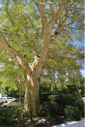
This is a fever tree. Interesting: If there is bad stuff in the earth, the tree designates one branch for the poisonous stuff, and will discard that branch when it cannot absorb any further poison. Then it will start another branch ...


On the way to the Cape...


Pretty nice, ahhh?


At the Cape of Good Hope...


Greetings from the Cape!

Wednesday, November 26, 2014

Goodbye Namibia - Hello South Africa

Goodbye Namibia – Hello South Africa


I am a bit behind with my blog. This is due to the fact, that;
 1. Internet is still an issues, and
 2. We have been soo busy sightseeing in and around Cape Town, I had no time to blog. But more about Cape Town later, first I will finish off Namibia.

It is bittersweet to say goodbye to Namibia, as it is an incredibly beautiful country. I loved every minute, and hopefully will come back another time.

After Duwisib and Luederitz, we start to make our way downward, towards South Africa. We are still on gravel roads, until we are done with them, our group will have had about 18 tire changes, and one vehicle needed a new clutch. We are lucky so far, we have had no issues.

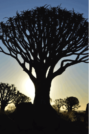
One of our overnight stops was at a place called the Quiver Tree Forest. I had no idea what a quiver tree was. At first I was really disappointed, as those trees did not quiver one bit, and a “forest” it wasn’t either. I guess if in the desert there are more than a handful of trees together, one can call it a forest. Later on I learned, that I was a bit silly, as quiver has two meanings, and in this case it meant the case where the Bushmen keep their arrows. This is, because the branches of these trees are hollow, and can be used as a “quiver”. Who knew!!!
I did enjoy this forest in the end, as the big attraction was to wait for sunset. Warren took some amazing pictures, I will try and post some off the best. Unfortunately I have to use a poorer copy to be able to upload to the blog.

Next, and the last stop of interest in Namibia was the Fish River Canyon. It’s not quite the Grand Canyon, but really nice. It is approximately half the age of our planet Earth, over 2 billion years old.


We cross into South Africa, it is still very dry and not very green. But bit-by-bit, we start to see more vegetation, shrubs, first small, then larger and larger. Same with trees. Then we come to the area of the “Olifant” river, and now we are talking. First wineries, lot’s of fruit trees, lot’s of lovely flowers, a feast for the eyes, after weeks and weeks of dust and desert. We also start to see the famous rooibos tea bushes. Field after field filled with them. We are a bit in shock. We camp at Lambert’s Bay, right beside the ocean, on a fantastic white, deserted sand beach. Next morning we make our way to Clanwilliam, to visit the Rooibos factory. We learn that the rooibos tea can only be grown in this specific corner of the world, nowhere else. No wonder all we see is rooibos. As I am a fan of this tea, I don’t mind seeing so much of it. The mountainous area where this can be grown is called the Cedar Mountains. Two weeks later we visit a world famous botanical garden outside of Cape Town, and we learn, that they have unsuccessfully tried to plant some of the rooibos there.


This is a Quiver Tree...


This is a Quiver Tree "Forest"


Now it get's interesting, Quiver Tree sunset...


And another one.....


On the same campground by the Quiver Trees, they had some "tame" Cheetahs, that Warren felt compelled to pet. I went into the cage to take the picture, pretty brave of me I thought!


It's a really beautiful animal... 


Here we see the Fish River Canyon. It's huge, the picture doesn't do it justice...


But not as big as the Grand Canyon...


Finally a picture of Warren and I together...


First glimpses of green, after weeks of brown and brown and brown. 


This is very young Rooibos, they grow much bigger than that. 


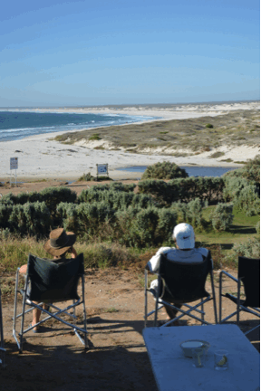
And after a hard day on the road, we get to enjoy this beautiful view at our campsite in Lambert's Bay.


Monday, November 24, 2014

Castle Duwisib - Namibia Nov. 12 - 15

Castle Duwisib/Aus/Luederitz – Namibia Nov. 12-15


After our very early morning adventure on the red sand dunes of Sossusflei, we still have a long day ahead of us, still on gravel roads. 180 km to be exact. We are tired before we even get going, and the roads are bad. Very bad. Lot’s of sharp rocks sticking out, lots of washboard. Our destination for the day is Castle Duwisib. We wonder about this. A castle in the middle of nowhere? We get there late in the afternoon and must wait to visit it until the next morning. There is a farm just next to the castle, and we have a group dinner there, and the owner talks to us about farming in Namibia. It is very interesting, and many questions are asked. It takes 13 hectares of land to raise one beef cow. That is a lot of land. Sometimes, during a drought, they may even have to load up their cattle and transport them to the Kalahari Desert, “board” them with other farmers until the drought is over.
Namibia has had very little rain the last three years, and several of his neighbours have gone broke. It is a hard life. As many of the farmers are of German descent (but Namibian born), some of them did have opportunities to go back to Germany. But most of them came back, even if life is hard in Namibia, they still preferred life here instead of Germany.

We visit the castle the next morning. What a crazy place to build a castle! A german noble man, who had married an American millionairess, build this place in 1908, and it was completed in 1909. That is less than two years!!! Only the red bricks came from Namibia, everything else was build and fabricated in Germany, shipped to Luederitz, and from there is was transported by Ox wagon to Duwisib. They did not get to live there for very long, because when the first world war started, the German owner joined the military and eventually died in a battle. His American wife did never go back to Namibia to live at Duwisib. (I don’t blame her, it’s definitely in the middle of nowhere!)

We travelled on to Aus and then to Luederitz. Luederitz is on the Atlantic coast, and we are parked right on the waters edge, facing west. There is a lot of wind, so much so, that you cannot sit outside, as the sand whips around and hurts your skin. And it get’s into your eyes, and ears, and nose, and everything else!
There are two excursions we do in Luederitz. The first one is to drive to Dias point. This is the spot, where the first European explorer Bartholomew Dias landed. The viewpoint is breathtaking, we are right on the cliffs, with breaking waves. We see sea lions, and I even spotted two dolphins. It was not easy to walk up to the top of the viewpoint, the wind almost blew us away.

The other place we visited was the ghost town of
Kolmanskop. In 1908, the first diamonds were found here, and started a “diamond-rush”. Since1950, the town has been abandoned and the desert is slowly taking it back. But some of it has been reclaimed and made into a tourist attraction.
After the tour is over, we are allowed to walk around town to go look at some of the houses. We only manage one, as the wind is so strong and the sand in our eyes makes us cranky!

Time to go back to Luederitz and sit inside the RV (with the doors and windows closed!) and enjoy a tall cool one.


Outside castle Duwisib, not so big, but nice inside .....


Looks very fancy, in the middle of nowhere...


Look from the upstairs balcony....


Nice Jacaranda tree, in full bloom....


We are soooooo excited to see paved roads, we had to take a picture....


We stop to see the wild horses along the way to Luederitz....


Not soo wild after all, they like the carrots I treated them with!!!


Our beautiful spot in Luederitz, right on the Atlantic ocean....


Luederitz harbour....


Ghost town of Kolmanskuppe....


One of the homes being lost to the desert....


The architects home....


Dias point, we had to hold on to the railing, the wind blew so hard....


Dias point, there are seals on the rocks and swimming in the water...